Trail Walking Le Passage - Le pont-canal, boulevard de l'eau - Pays de l'Agenais - Photo

Le pont-canal, boulevard de l'eau - Pays de l'Agenais

 tracegps
tracegps

User

© OpenStreetMap contributors
Length
Length
7.1 km
Max alt
Max alt
53 m
Uphill gradient
Uphill gradient
46 m
Km-Effort
Km-Effort  
7.7 km
Min alt
Min alt
39 m
Downhill gradient
Downhill gradient
51 m
Boucle
Boucle
Yes
Creation date :
2014-12-10 00:00:00.0
Updated on :
2014-12-10 00:00:00.0

(0 Reviews)

Walking
Walking
2h00
Difficulty : Medium

Scan this QR Code to open this trail in the SityTrail application

FREE GPS app for hiking

Logo SityTrail SityTrail

IGN / Geographical institutes

Download SityTrail from the App Store Download SityTrail from Google Play

Logo SityTrail SityTrail World

The world is yours!

Download SityTrail from the App Store Download SityTrail from Google Play Download SityTrail on Huawei AppGallery

About

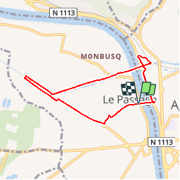
Trail Walking of 7.1 km to be discovered at New Aquitaine, Lot-et-Garonne, Le Passage. This trail is proposed by tracegps.

Description

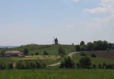
Le Passage Communauté d’Agglomération d’Agen. La Garonne et son canal rythment cette promenade qui longe d’abord le paisible canal de Garonne avant de franchir deux fois le fleuve, sur le pont-canal, puis sur la nouvelle passerelle suspendue. Téléchargez la fiche de cette randonnée sur le site du Tourisme du Lot et Garonne.

Elevation profile

Photos

Positioning

Country:
France
Region :
New Aquitaine
Department/Province :
Lot-et-Garonne
Municipality :
Le Passage
Location:
Unknown
Start:(UTM)
308739 ; 4897068 (31T) N.

Trails nearby

Trail Walking Colayrac-Saint-Cirq - Randonnée dans les collines Agenaises - Colayrac Saint Cirq - Photo
Walking
tracegps

Walking

Medium
(2)
Colayrac-Saint-Cirq, New Aquitaine, Lot-et-Garonne, France
11.7 km | 15.8 km-effort
3h 10min
Yes
Trail Bicycle tourism Agen - Agen-Moissac - Photo
Bicycle tourism
ilur56

Bicycle tourism

Medium
Agen, New Aquitaine, Lot-et-Garonne, France
51 km | 55 km-effort
Unknown
No
Trail Walking Foulayronnes - Randonnée aux environs d'Agen et le Passage d'Agen - Photo
Walking
Forsans

Walking

Easy
Foulayronnes, New Aquitaine, Lot-et-Garonne, France
10.6 km | 12.2 km-effort
3h 12min
Yes
Trail Walking Boé - Passeligne pélissier - Photo
Walking
gege47

Walking

Very easy
Boé, New Aquitaine, Lot-et-Garonne, France
5 km | 5.5 km-effort
1h 10min
Yes
Trail Mountain bike Estillac - Moirax - Photo
Mountain bike
tracegps

Mountain bike

Very difficult
(1)
Estillac, New Aquitaine, Lot-et-Garonne, France
42 km | 53 km-effort
3h 0min
Yes
Trail Walking Pont-du-Casse - la candelie test 02 05 23 - Photo
Walking
mdns

Walking

Easy
Pont-du-Casse, New Aquitaine, Lot-et-Garonne, France
3.7 km | 4.9 km-effort
1h 32min
Yes
Trail Mountain bike Colayrac-Saint-Cirq - Randonnée dans les collines Agenaises - Colayrac Saint Cirq - Photo
Mountain bike
tracegps

Mountain bike

Easy
Colayrac-Saint-Cirq, New Aquitaine, Lot-et-Garonne, France
11.7 km | 15.8 km-effort
1h 30min
Yes
Trail Walking Foulayronnes - Foulayronnes, les ailes du moulin de Talives - Pays de l'Agenais - Photo
Walking
tracegps

Walking

Medium
(1)
Foulayronnes, New Aquitaine, Lot-et-Garonne, France
5.9 km | 7.8 km-effort
1h 40min
Yes
Trail Equestrian Foulayronnes - Foulayronnes / Monbran, Chemin de Saint-Jacques - Pays de l'Agenais - Photo
Equestrian
tracegps

Equestrian

Medium
Foulayronnes, New Aquitaine, Lot-et-Garonne, France
8.4 km | 12.1 km-effort
1h 30min
Yes


Close
My subscriptions